Esto es todo lo que aparece en ESTOFEX, aparte de los reportes, claro... hilaron fino y acertaron en su pronostico...

Storm Forecast
Valid: Fri 15 Aug 2008 06:00 to Sat 16 Aug 2008 06:00 UTC
Issued: Thu 14 Aug 2008 21:16
Forecaster: TUSCHY/GROENEMEIJER
* * * A major severe-weather outbreak is forecast for parts of the central Mediterranean, the northwestern Balkans and parts of central Europe. Severe thunderstorms with tornadoes, damaging wind gusts and significant hail can be expected. * * *
SYNOPSIS
A very dynamic upper-level trough, centered over France during the morning hours, is on its way to the east, approaching the Alpine region during the late afternoon/evening hours as a negative tilted and still strengthening upper trough. This feature dictates the weather over most parts of Europe as intense WAA downstream of this system spreads northeastwards, while much cooler and more stable air infiltrates NW Europe. Between both airmasses, a quasi-stationary and undulating frontal boundary has established during the past days. This boundary changes into a cold front over central Italy, Austria, the Czech Republic, and SW Poland, and into a northward advancing warm front over central and northern Poland. Very hot conditions continue over the central Mediterranean, eastern and southeastern Europe.
...Poland...
The aforementioned wavy frontal boundary will get modified by the developing surface depression over Poland and is expected to move northward across Poland as a warm front. Cold air slowly advances from the W during the evening/night hours. The warm sector, which covers most parts of Poland, is characterized by a warm boundary-layer with dewpoints near 20°C in vicinity of the frontal zones. Shear along the warm front and next to the depression's center should increase during the day with locally up to 20 m/s low-level shear and 0-1 km storm-relative helicity values of more than 300 m^2/s^2. LCL heights should be low near and just north of the warm front. Each thunderstorm that develops near this boundary has a high chance to acquire strong low-level rotation and produce strong tornadoes. During the late afternoon hours, the low-level wind field increases even further with readings of more than 25 m/s at 850 hPa. This not only increases the risk of rotating storms, but enhances the risk for damaging wind gusts as well. Numerical models suggest that storms may cluster across central and/or northern Poland and subsequently move northeastward into Lithuania and further northeastward. If such a cluster develops, it could well develop into a bow echo with widespread damaging winds. In comparison with the Extended Forecast issued earlier, we have upgraded parts of the area to a level 3 because a regional tornado outbreak appears very well possible in addition to damaging wind gusts.
Both shear and instability values are also impressive over SW Poland, but directional shear should be much weaker. This should help to abate the tornado risk, but storms moving off the hodograph could still produce tornadoes. The main risk will be a severe-damaging wind gust and isolated large hail threat as shear at the lowest 3km increases to 25m/s.

Horas despues actualizaron...
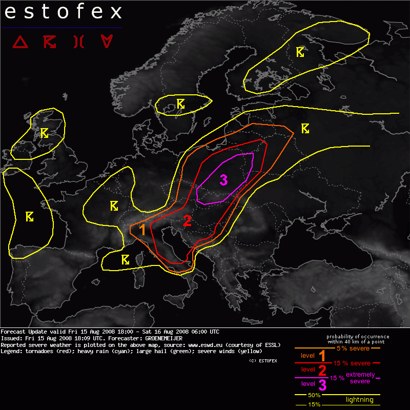
Forecast Update
Valid: Fri 15 Aug 2008 18:00 to Sat 16 Aug 2008 06:00 UTC
Issued: Fri 15 Aug 2008 18:09
Forecaster: GROENEMEIJER
+ + + TORNADO OUTBREAK CURRENTLY UNDERWAY ACROSS SOUTHERN AND CENTRAL POLAND AND POSSIBLY SLOVAKIA EXPECTED TO CONTINUE THROUGH THE EVENING + + +
DISCUSSION
S and E Poland... Slovakia... E Czech Rep...
A line of supercells with reported tornadoes are ongoing across a line from just west of Warsaw to Krakow to Bratislava. These are expected to continue during the evening while moving eastward. As a southerly nocturnal low-level jet sets in across the Pannonian Plain and the Carpates, and the pressure gradient increases due to pressure falls east of the Alps, low-level shear profiles are expected to improve further. A continued threat of supercells producing (strong) tornadoes, very large hail and damaging winds is forecast. Storms may weaken no sooner than well after midnight.
E Austria... W and C Hungary
Strong storm-relative helicity of around 400 m2/s2 is expected to develop across extreme eastern Austria and the western half Hungary during the evening in reponse to pressure falls over Hungary. Storm that develop in this environment would have a high probability of producing tornadoes, also given the moist boundary layer that is present, with expceptionally high dew points of 23 C observed. The most important question is whether and if yes, how many storms will develop. Currently, we anticipate that isolated to scattered storms will develop, possibly clustering into a small MCS. An attendant threat of tornadoes, including strong tornadoes, as well as large hail and damaging gusts is forecast. Only after midnight should the boundary layer cool sufficiently to mitigate the severe threat.
 Tema: Oleada de tornados (Tornadic Outbreak) en el Sur de Polonia y Eslovaquia !! (Leído 4890 veces)