Buscas algun articulo o informacion? usa nuestro buscador
Síguenos también en:


Facebook


Autor Tema: Gran Huracan Edouard 06L, categoria 3, Atl. Norte Central  (Leído 6470 veces)

Desconectado Gale

  • Webmaster - Admin
  • Tornado F5 (Dedo de Dios)
  • ******
  • Mensajes: 45.768
    • Cazatormentas.Net
Re:Gran Huracan Edouard 06L, categoria 3, Atl. Norte Central
« Respuesta #75 en: Septiembre 17, 2014, 15:26:51 pm »
La verdad es que la animación MIMIC de Edouard muestra unos topes nubosos con más brillo, lo que significa convección más activa, y también un doble eyewall, que quiere decir que el ciclón no logra completar un ciclo de reemplazamiento del ojo. Vamos, está luchando como un campeón ;D ;D ;D


Desconectado Gale

  • Webmaster - Admin
  • Tornado F5 (Dedo de Dios)
  • ******
  • Mensajes: 45.768
    • Cazatormentas.Net
Re:Gran Huracan Edouard 06L, categoria 3, Atl. Norte Central
« Respuesta #76 en: Septiembre 17, 2014, 17:19:54 pm »
Reciente actualización del boletín del CNH: mantiene dos anillos convectivos concéntricos, intentando ejecutar un ciclo de reemplazamiento del ojo, pero sin terminar de realizarlo. Además, destaca que la presión es bastante baja, estimada en 958 hPa por el último vuelo cazahuracanes, pero con vientos mantenidos en 80 KT debido a que el gradiente de presión no es lo suficientemente grande para redundar en una mayor intensidad de estos.

Resulta muy llamativo una presión de 958 hPa para un huracán de categoría 1............ :o :o

Veremos cómo se comporta porque, aunque la cizalladura aumenta, su velocidad de traslación también, por lo que vectores cizalladura y movimiento del ciclón están alineados y solo la diferencia de estos puede resultar en una cizalladura prohibitiva para el mantenimiento de la verticalidad del ciclón...

Citar
000
WTNT41 KNHC 171457
TCDAT1

HURRICANE EDOUARD DISCUSSION NUMBER  25
NWS NATIONAL HURRICANE CENTER MIAMI FL       AL062014
1100 AM AST WED SEP 17 2014

Edouard is maintaining two concentric rings as indicated in the
latest visible satellite images and recent NOAA Hurricane Hunter
aircraft wind data
.  Even though the central pressure is rather low,
958 mb, the pressure gradient is spread out over the large area
comprising the two rings, leading to a lower peak wind than a
typical cyclone would have. Flight-level and SFMR winds still
support an intensity of about 80 kt, which is unchanged from the
previous estimate.

Edouard is accelerating northeastward with a motion of 045/20 kt.
The hurricane is being steered by mid-latitude flow between the
subtropical ridge and a broad trough over the western Atlantic
Ocean.  This pattern should force Edouard to move faster toward the
east-northeast by late tonight, and eastward by late tomorrow.   In
a couple of days, Edouard (or its remnants) should turn southward
to the west of the Azores around a large trough over the eastern
Atlantic Ocean.  The track guidance remains tightly clustered for
the first 48 hours but continues to show some divergence during
the post-tropical phase.  The ECMWF has remained consistent on a
sharper southward turn, while the GFS is showing a more gradual
equatorward motion.  Because of the consistency of the ECMWF during
the past few runs, the latest NHC track is staying on the southwest
side of the model envelope at long range, roughly halfway between
the model consensus and the ECMWF.

Edouard is moving quickly toward the northeast and should pass over
waters cooler than 26C in less than 12 hours
.  Only a gradual
weakening is shown during the first 24 hours due to cooler waters
and moderate shear.  All of the global models show a sharp increase
in shear after that time while the cyclone is moving over much
colder water.  Thus a more rapid weakening is shown beginning late
tomorrow, which is similar to a blend of the previous NHC forecast,
the Florida State Superensemble, and the intensity consensus.  The
cyclone is expected to become post-tropical in 2 or 3 days, which
is in good agreement with the global models.  Although Edouard is
expected to traverse warmer waters by the end of the forecast
period, strong northwesterly shear is anticipated to hinder any
redevelopment potential.


FORECAST POSITIONS AND MAX WINDS

INIT  17/1500Z 36.4N  53.3W   80 KT  90 MPH
 12H  18/0000Z 38.3N  49.9W   75 KT  85 MPH
 24H  18/1200Z 39.8N  44.7W   70 KT  80 MPH
 36H  19/0000Z 40.1N  40.7W   55 KT  65 MPH
 48H  19/1200Z 39.7N  38.7W   40 KT  45 MPH
 72H  20/1200Z 39.4N  35.8W   35 KT  40 MPH...POST-TROPICAL
 96H  21/1200Z 37.5N  33.5W   30 KT  35 MPH...POST-TROPICAL
120H  22/1200Z 34.5N  33.0W   30 KT  35 MPH...POST-TROPICAL

$$
Forecaster Blake


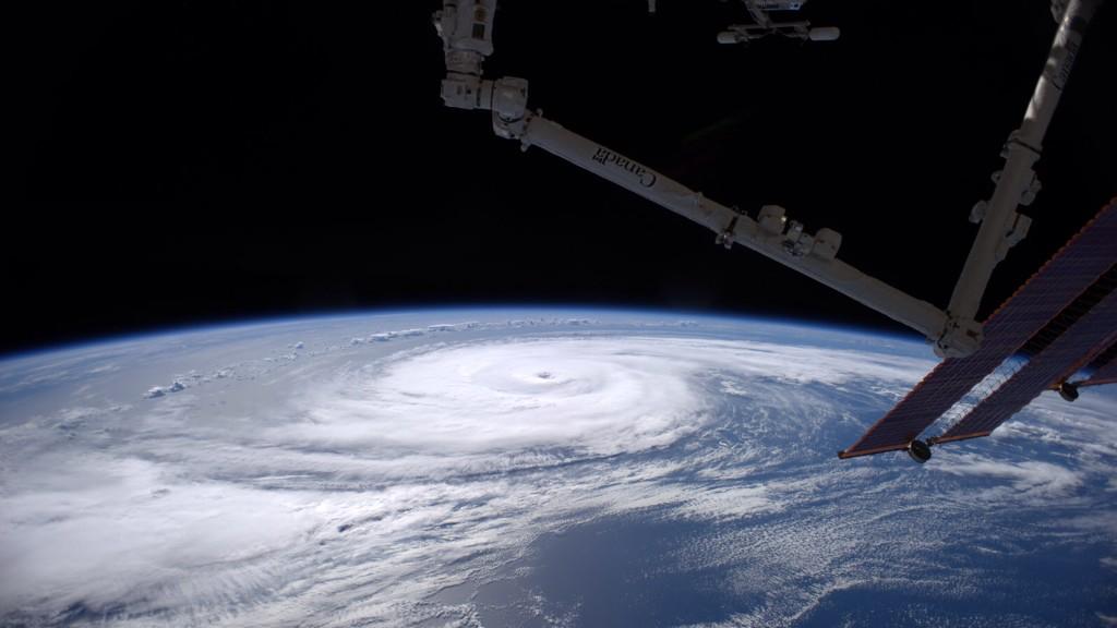
Y la última imagen de Edouard desde la Estación Espacial Internacional, por el astronauta Reid Wiseman

Citar
Reid Wiseman ‏@astro_reid 47 min
#Edouard - Perhaps the most perfectly shaped #hurricane ever created by nature.

Desconectado jota

  • Informando desde Málaga @Jota__Pex
  • Webmaster - Admin
  • Tornado F5 (Dedo de Dios)
  • ******
  • Mensajes: 41.595
  • Ingeniero y meteorólogo frustrado
    • cazatormentas.net
Re:Gran Huracan Edouard 06L, categoria 3, Atl. Norte Central
« Respuesta #77 en: Septiembre 17, 2014, 23:35:00 pm »
Is #Eduoard another "Nadine (2012)" scenario? ECMWF keeps the tropical cyclone around for the next 10 days #HS3


"Escápate de tu tiempo
al tiempo que no transcurre.
Pon tu mirada por
encima de tu yo, tu día, tu orden...
Yo-Día-Orden-Caos"

(José Val del Omar)

www.cazatormentas.net   https://twitter.com/Jota__Pex
jota@cazatormentas.net

Desconectado Eyestorm_Eric

  • Hurricane Hunters - Cazahuracanes
  • Tornado F1
  • *****
  • Mensajes: 1.081
  • En el ojo de la tormenta esta la calma absoluta
    • Foro de Meteorología de Venezuela
Re:Gran Huracan Edouard 06L, categoria 3, Atl. Norte Central
« Respuesta #78 en: Septiembre 18, 2014, 03:19:06 am »
Hora local de Caracas 8:45pm

Continúa su progresivo debilitamiento, sin embargo mantiene una presión mínima correspondiente a un CAT3   :o :o

SUMMARY OF 500 PM AST...2100 UTC...INFORMATION
----------------------------------------------
LOCATION...37.8N 51.2W
ABOUT 855 MI...1380 KM ENE OF BERMUDA
ABOUT 1220 MI...1960 KM W OF FAYAL ISLAND IN THE WESTERN AZORES
MAXIMUM SUSTAINED WINDS...85 MPH...140 KM/H
PRESENT MOVEMENT...NE OR 55 DEGREES AT 26 MPH...43 KM/H
MINIMUM CENTRAL PRESSURE...958 MB...28.29 INCHES

La cizalladura y las aguas frías del Atlántico hacia donde se desplaza lo condenan a seguir debilitándose:


La estructura ovalada sugiere que ya la cizalladura está haciendo mella en el sistema


Satélite visible vespertino:

Caracas, Venezuela

@meteovenezuela
@climavzla

Desconectado Gale

  • Webmaster - Admin
  • Tornado F5 (Dedo de Dios)
  • ******
  • Mensajes: 45.768
    • Cazatormentas.Net
Re:Gran Huracan Edouard 06L, categoria 3, Atl. Norte Central
« Respuesta #79 en: Septiembre 18, 2014, 09:40:20 am »
Durante todo el día de ayer mantuvo dos anillos convectivos concéntricos, dos eyewall, en un proceso de ciclo de reemplazamiento del ojo que no parece que llegase a completarse, lo cual no sabremos exactamente hasta que no se actualice el producto del CIMSS.


Desconectado Gale

  • Webmaster - Admin
  • Tornado F5 (Dedo de Dios)
  • ******
  • Mensajes: 45.768
    • Cazatormentas.Net
Re:Gran Huracan Edouard 06L, categoria 3, Atl. Norte Central
« Respuesta #80 en: Septiembre 18, 2014, 09:43:17 am »
Por otro lado, aunque en la animación del IR+RGB se ve la desaparición progresiva del ojo, el nivel de convección y la simetría sigue manteniéndose bastante buena.

Es posible que, a pesar de que ayer el CNH dijera que el ciclón se iba a mantener lejos de recibir una interacción positiva con inestabilidad baroclina, quizás esto no esté siendo así y el ciclón esté apoyándose en este mecanismo para mantener su convección y maquinaria térmica interna.


Desconectado Gale

  • Webmaster - Admin
  • Tornado F5 (Dedo de Dios)
  • ******
  • Mensajes: 45.768
    • Cazatormentas.Net
Re:Gran Huracan Edouard 06L, categoria 3, Atl. Norte Central
« Respuesta #81 en: Septiembre 18, 2014, 09:49:25 am »
Is #Eduoard another "Nadine (2012)" scenario? ECMWF keeps the tropical cyclone around for the next 10 days #HS3


Esto es interesante, aunque ya veremos qué ocurre. El europeo IFS lo hace desaparecer con mucha rapidez, más que el GFS... Mañana aún se mantendrá con un fuerte reflejo en superficie; pero pasado, casi desaparece...


Desconectado Gale

  • Webmaster - Admin
  • Tornado F5 (Dedo de Dios)
  • ******
  • Mensajes: 45.768
    • Cazatormentas.Net
Re:Gran Huracan Edouard 06L, categoria 3, Atl. Norte Central
« Respuesta #82 en: Septiembre 18, 2014, 12:09:26 pm »
No os perdáis la galería de fotos hechas por las incursiones de aviones cazahuracanes en el seno de Edouard! :o :o :o :o

Mientras tanto, indicar que parece que los meteos del CNH se pasan por este hilo a leer ;D ;D ;D

Citar
000
WTNT41 KNHC 180849
TCDAT1

HURRICANE EDOUARD DISCUSSION NUMBER  28
NWS NATIONAL HURRICANE CENTER MIAMI FL       AL062014
500 AM AST THU SEP 18 2014

An 0426 UTC GCOM microwave pass showed that Edouard has a small,
solid inner eyewall
surrounded by a thinning outer ring of deep
convection.  The infrared satellite presentation has not changed
appreciably from 6 hours ago, and the initial intensity is held at
75 kt based on a blend of Dvorak estimates from TAFB, SAB, and the
UW-CIMSS ADT.  Edouard is over 24C water, but there is still some
atmospheric instability available for the hurricane to maintain its
convective structure
.  However, the SHIPS guidance shows the
instability decreasing and westerly vertical shear increasing over
30 kt during the next 24 hours, so Edouard is expected to begin a
faster weakening trend later today.  The hostile conditions should
cause Edouard to lose all of its deep convection in 36-48 hours,
and the official forecast still calls for the system to be a
post-tropical low in 48 hours and dissipate by day 5.  The NHC
forecast is just an update of the previous one and closely follows
the ICON intensity consensus.

The hurricane appears to be slowing down just a little bit and has
an initial motion of 065/24 kt.  Edouard is moving around the
northern side of a mid-tropospheric high located over the central
Atlantic, and it is forecast to turn eastward and then southeastward
around this feature during the next 3 days.  Most of the track
models are in good agreement on this scenario.  The two main
outliers are the UKMET, which shows a sharper southward turn after
12 hours, and the GFDL, which shows Edouard continuing to race
northeastward ahead of a cold front.  The updated NHC track forecast
is close to a consensus of the GFS, ECMWF, and HWRF models and is a
little south and west of the previous forecast after 48 hours.

FORECAST POSITIONS AND MAX WINDS

INIT  18/0900Z 39.6N  45.3W   75 KT  85 MPH
 12H  18/1800Z 40.1N  41.9W   65 KT  75 MPH
 24H  19/0600Z 39.9N  38.8W   50 KT  60 MPH
 36H  19/1800Z 39.7N  37.2W   40 KT  45 MPH
 48H  20/0600Z 39.7N  35.6W   35 KT  40 MPH...POST-TROPICAL
 72H  21/0600Z 38.5N  31.1W   30 KT  35 MPH...POST-TROPICAL
 96H  22/0600Z 35.0N  30.0W   30 KT  35 MPH...POST-TROPICAL
120H  23/0600Z...DISSIPATED

$$
Forecaster Berg

Desconectado Gale

  • Webmaster - Admin
  • Tornado F5 (Dedo de Dios)
  • ******
  • Mensajes: 45.768
    • Cazatormentas.Net
Re:Gran Huracan Edouard 06L, categoria 3, Atl. Norte Central
« Respuesta #83 en: Septiembre 18, 2014, 12:20:09 pm »
En las imágenes satelitales de Azores, ya comienza a asomar por el oeste... además, la corriente en chorro que tiene al norte le está comenzando a arrancar nubosidad, que ya roza el archipiélago...


Desconectado Gale

  • Webmaster - Admin
  • Tornado F5 (Dedo de Dios)
  • ******
  • Mensajes: 45.768
    • Cazatormentas.Net
Re:Gran Huracan Edouard 06L, categoria 3, Atl. Norte Central
« Respuesta #84 en: Septiembre 18, 2014, 15:28:19 pm »
Comienzan a aparecer síntomas de inicio de la Transición Extratropical en Edouard............. :-\


Desconectado Gale

  • Webmaster - Admin
  • Tornado F5 (Dedo de Dios)
  • ******
  • Mensajes: 45.768
    • Cazatormentas.Net
Re:Gran Huracan Edouard 06L, categoria 3, Atl. Norte Central
« Respuesta #85 en: Septiembre 18, 2014, 15:33:57 pm »
Este sí que sería un gran viaje.............. Especialmente si al volver a aguas tropicales decide volver a desarrollarse... :D1 :D1 :D1


Desconectado Gale

  • Webmaster - Admin
  • Tornado F5 (Dedo de Dios)
  • ******
  • Mensajes: 45.768
    • Cazatormentas.Net
Re:Gran Huracan Edouard 06L, categoria 3, Atl. Norte Central
« Respuesta #86 en: Septiembre 18, 2014, 15:53:01 pm »
Ojito a todo lo que podemos aprender hoy con Edouard y Eumetrain sobre la naturaleza de los ciclones tropicales, aunque sea las últimas horas de vida de estos...

Edouard, justo al sur del Chorro Polar, pero rodeado de aire seco y comenzando la transición extratropical por el impacto de este y de la fuerte cizalladura vertical del viento desacoplando los centros y comenzando a desnudarle la convección. Marcado reflejo en niveles bajos y medios, pero si añadimos el campo de isohipsas de 300 hPa, apenas sí aparece reflejo (tan solo una isohipsa cerrada).

« Última modificación: Septiembre 18, 2014, 15:56:43 pm por Gale »

Desconectado Gale

  • Webmaster - Admin
  • Tornado F5 (Dedo de Dios)
  • ******
  • Mensajes: 45.768
    • Cazatormentas.Net
Re:Gran Huracan Edouard 06L, categoria 3, Atl. Norte Central
« Respuesta #87 en: Septiembre 18, 2014, 15:57:43 pm »
Y añado otra figura, que completa a lo que decía en el anterior post...


Desconectado Gale

  • Webmaster - Admin
  • Tornado F5 (Dedo de Dios)
  • ******
  • Mensajes: 45.768
    • Cazatormentas.Net
Re:Gran Huracan Edouard 06L, categoria 3, Atl. Norte Central
« Respuesta #88 en: Septiembre 18, 2014, 16:11:28 pm »
El HIRLAM de AEMET aún refleja de forma más clara la naturaleza cálida del núcleo del ciclón tropical 8)

Desconectado Gale

  • Webmaster - Admin
  • Tornado F5 (Dedo de Dios)
  • ******
  • Mensajes: 45.768
    • Cazatormentas.Net
Re:Gran Huracan Edouard 06L, categoria 3, Atl. Norte Central
« Respuesta #89 en: Septiembre 18, 2014, 17:43:48 pm »
CNH actualizó el boletín hace rato, y viene a explicar lo que hemos estado comentando....

Citar
000
WTNT41 KNHC 181436
TCDAT1

HURRICANE EDOUARD DISCUSSION NUMBER  29
NWS NATIONAL HURRICANE CENTER MIAMI FL       AL062014
1100 AM AST THU SEP 18 2014

A 0906 UTC SSMIS pass showed that the eyewall of Edouard had opened
up on the southwest side
and the circulation was becoming somewhat
tilted with height
. This tilt was confirmed by an ASCAT pass around
1230 UTC. The coverage of cold convective tops is gradually
decreasing, and the initial intensity is lowered to 70 kt based on a
blend of subjective and objective Dvorak estimates from TAFB, SAB,
and UW-CIMSS. Given that the cyclone will be moving over cooler
waters and experiencing increased vertical wind shear, steady
weakening is expected during the next 24 hours. Edouard should lose
its deep convection in 36 to 48 hours and become post-tropical by
that time
. Global model fields show the circulation of Edouard
dissipating by the end of the period, and that is reflected in the
official forecast. The new NHC intensity forecast is an update of
the previous one and is close to the IVCN multi-model consensus.

The initial motion estimate is now eastward, or 085/22, as Edouard
is currently located north of a mid-level ridge over the central
Atlantic. The cyclone will move eastward and then southeastward
around this ridge during the next 72 hours, and then turn southward
by day 4. Most of the track model guidance remains in good agreement
on this scenario, with the continued exception of the GFDL and
UKMET which show a more northeastward and southward motion,
respectively. The new NHC track forecast is close to a consensus of
the GFS and ECMWF models, and is similar to the previous advisory.

The initial wind radii were modified based on data from the
above-mentioned ASCAT pass.

FORECAST POSITIONS AND MAX WINDS

INIT  18/1500Z 39.9N  42.7W   70 KT  80 MPH
 12H  19/0000Z 40.1N  39.9W   60 KT  70 MPH
 24H  19/1200Z 39.9N  37.8W   45 KT  50 MPH
 36H  20/0000Z 40.0N  36.2W   35 KT  40 MPH
 48H  20/1200Z 40.0N  34.3W   35 KT  40 MPH...POST-TROPICAL
 72H  21/1200Z 37.5N  30.0W   30 KT  35 MPH...POST-TROP/REMNT LOW
 96H  22/1200Z 33.0N  30.0W   30 KT  35 MPH...POST-TROP/REMNT LOW
120H  23/1200Z...DISSIPATED

$$
Forecaster Brennan


Buscas algun articulo o informacion? usa nuestro buscador