Buscas algun articulo o informacion? usa nuestro buscador
Síguenos también en:


Facebook


Autor Tema: Seguimiento de Tormentas. Diciembre 2006  (Leído 3242 veces)

storm2002

  • Visitante
Seguimiento de Tormentas. Diciembre 2006
« en: Diciembre 01, 2006, 12:22:38 pm »
Veo que no habia abiero ningun topic referente a las tormentas del nuevo mes...
Segun ESTOFEX


Y esto es lo que hace un momento tenian en la costa de Valencia hacia el mar  :-X :-X


http://webcam.comunitatvalenciana.com/webcam2.htm?id_camara=78

Saludos ;)

storm2002

  • Visitante
Re: Seguimiento de Tormentas. Diciembre 2006
« Respuesta #1 en: Diciembre 02, 2006, 09:09:02 am »
Hoy puede ser un buen dia, en el SW y en las costas de Cataluña
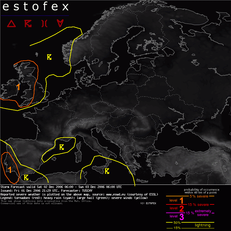


SYNOPSIS

An outstanding dynamic weather pattern continues over the North Atlantic.
Latest CMC analysis (01.12.) indicated a whopping upper level jet streak with up to 185 kt over far eastern Canada, also supported by the 12Z sounding of YZV Sept-Iles, reporting even 190 kt at 300 hPa.
This intense jet will rapidly develop towards the SE during the next 24 hours, inducing an intense cyclogenesis somewhere around 55N 20W, nearly matching the criteria for a rapid cyclogenesis.
The 12Z outlook of the Ocean Prediction Center levels it off at about 953 hPa north of Ireland just after the end of the forecast period.
Further towards the south, a spacious upper-level trough will cross Portugal and Spain, supporting an active period regarding convective activity.
Strong high pressure area will still be present over the rest of Europe although smaller scale disturbances support localized enhanced convective activity over parts of the Mediterranean.


Desconectado alb_Ronda

  • Moderador del foro.
  • Tornado F5 (Dedo de Dios)
  • *****
  • Mensajes: 13.954
  • Actualmente en Barcelona
Re: Seguimiento de Tormentas. Diciembre 2006
« Respuesta #2 en: Diciembre 02, 2006, 12:21:58 pm »
Puntos verdes al Este de Malaga. Los puntos son bien chicos y cuesta un huevo verlo


-- Actualmente desde Barcelona --
Soy de una ciudad donde llueve hacia arriba y a los pájaros se les ve el lomo mientras vuelan
***

storm2002

  • Visitante
Re: Seguimiento de Tormentas. Diciembre 2006
« Respuesta #3 en: Diciembre 02, 2006, 15:13:34 pm »
Puntos verdes al Este de Malaga. Los puntos son bien chicos y cuesta un huevo verlo


Estos de Weather Online lo han cagado con los puntitos :-X

Desconectado Davis

  • El Guardián de las Palabras
  • Tornado F1
  • *
  • Mensajes: 2.726
  • Málaga Tornado Alley
Re: Seguimiento de Tormentas. Diciembre 2006
« Respuesta #4 en: Diciembre 02, 2006, 17:02:54 pm »
Puntos verdes al Este de Malaga. Los puntos son bien chicos y cuesta un huevo verlo

Estos de Weather Online lo han cagado con los puntitos :-X

Al menos se ve donde ha caido el rayo de forma más exacta. Antes con un puntarraco en Málaga el rayo podia haber caido desde el Rincon a Fuengirola, por poner un ejemplo.  :P
Eso si, habrá que sacar la lupa del paint para verlos  :-X

Desconectado abraham

  • Tornado F1
  • *
  • Mensajes: 408
Re: Seguimiento de Tormentas. Diciembre 2006
« Respuesta #5 en: Diciembre 02, 2006, 22:39:35 pm »
hace menos de 1 hora ha estado haciendo tormenta en velez-malaga,aunque no se ha acercado mucho 

saludos  ;)
reportando desde VELEZ-MALAGA

storm2002

  • Visitante
Re: Seguimiento de Tormentas. Diciembre 2006
« Respuesta #6 en: Diciembre 03, 2006, 10:19:24 am »
hace menos de 1 hora ha estado haciendo tormenta en velez-malaga,aunque no se ha acercado mucho 

saludos  ;)

Efectivamente , esa era la tormenta que anoche anduvo por Chilches y localidades cercanas. Yo estuve de caza y la verdad que se acercó bastante a Velez Málaga, donde llovió bastante bien pero sin rayos ;)

Desconectado seal

  • Alhaurin el Grande (Málaga) 300 msnm
  • Piernas de Acero
  • Tornado F5 (Dedo de Dios)
  • *****
  • Mensajes: 20.707
    • Hasta la Cima
Re: Seguimiento de Tormentas. Diciembre 2006
« Respuesta #7 en: Diciembre 12, 2006, 09:17:12 am »
Algo da estofex:


Alhaurin el Grande (Málaga) 300 msnm.
Dani en TWITTER

Hastalacima

storm2002

  • Visitante
Re: Seguimiento de Tormentas. Diciembre 2006
« Respuesta #8 en: Diciembre 12, 2006, 12:24:39 pm »
Si Dani pero de momento no hay nada absolutamente... ni aqui ni en Africa ni en ningun lado :</O

ermuleto

  • Visitante
Re: Seguimiento de Tormentas. Diciembre 2006
« Respuesta #9 en: Diciembre 15, 2006, 09:16:33 am »
Cayendo la de Dios en Canovellas. He mirado el radar del Meteocat pero no va, parece que está entrando núcleos tormentosos desde el mar.

ermuleto

  • Visitante
Re: Seguimiento de Tormentas. Diciembre 2006
« Respuesta #10 en: Diciembre 15, 2006, 09:24:07 am »
Situación interesante se nos presenta hoy en Cataluña.


storm2002

  • Visitante
Re: Seguimiento de Tormentas. Diciembre 2006
« Respuesta #11 en: Diciembre 15, 2006, 10:19:38 am »
Estofex para hoy también lo corrobora... :D


Storm Forecast
Valid: Fri 15 Dec 2006 06:00 to Sat 16 Dec 2006 06:00 UTC
Issued: Thu 14 Dec 2006 21:33
Forecaster: GATZEN

SYNOPSIS

A sharp ridge axis connects eastern Atlantic ridge with a high over central Europe and Balkans. At its northern flank, a very strong jet streak travels eastward over southern Scandinavia during the forecast period. To the south, a cut-off low over northern Algeria remains. Instable air masses north of the jet streak as well as in the range of the cut off will lead to some convection on Friday.

DISCUSSION

Western Mediterranean

Situation over western Mediterranean is comparable to Thursday: An easterly surface flow advects rather moist low-level maritime air mass in a region with rather steep lapse rates in the range of the upper trough. Latest models indicate that instability will spread to the north and west as low-level dry continental air mass from Algeria advects northward. Given weak CIN, showers and thunderstorms will likely go on further north during the period. Organized thunderstorms seem to be not very likely as deep layer vertical wind shear will only be around 10 m/s. However, a southerly jet curving around the cut off is expected alond the Tunisian coast late in the period, and deep layer wind shear will increase. A few organized thunderstorms are forecast to develop, but chance for severe weather is expected to be weak, though. Strong wind gusts and small hail are forecast. Best potential for some tornadoes exists near the coasts of Tunisia and Corsica, where low-level vertical wind shear is expected to reach more than 10 m/s in the range of south-easterly low-level jet. Current decision is not to issue a level 1 due to rather weak deep layer wind shear and weakeining thermodynamic profiles compared to Thursday.


ermuleto

  • Visitante
Re: Seguimiento de Tormentas. Diciembre 2006
« Respuesta #12 en: Diciembre 15, 2006, 10:41:27 am »
Nuevos núcleos tormentosos formándose en el mar.  evil


ermuleto

  • Visitante
Re: Seguimiento de Tormentas. Diciembre 2006
« Respuesta #13 en: Diciembre 15, 2006, 10:42:15 am »
Precipitación recogida hasta el momento.


Mataró:  11.9 mm

Canovellas y Granollers:  5.4 mm

Premia de Mar:  6.6 mm

Cerdanyola:  3.2 mm


Datos extraidos de: 

http://www.tempsgranollers.com/ 
http://www.tempsmataro.net
http://www.telefonica.net/web2/meteopremia/
http://www.telefonica.net/web2/meteocerdanyola/
« Última modificación: Diciembre 15, 2006, 10:44:07 am por Ermuleto »

Desconectado Chaparrón

  • Acamet
  • Tornado F5 (Dedo de Dios)
  • *****
  • Mensajes: 23.001
  • Cañete la Real - 780 m
Re: Seguimiento de Tormentas. Diciembre 2006
« Respuesta #14 en: Diciembre 15, 2006, 11:33:49 am »
Está la pequeña dana bien marcada por las tormentas.
A las 11 de la mañana... :o
Entre Málaga, Cañete la Real, y Motril.


Buscas algun articulo o informacion? usa nuestro buscador