Buscas algun articulo o informacion? usa nuestro buscador
Síguenos también en:


Facebook


Autor Tema: Supercélulas en Serbia,año 2008.  (Leído 4962 veces)

Desconectado pavlovic

  • Cazatornados
  • Tornado F1
  • *****
  • Mensajes: 462
Supercélulas en Serbia,año 2008.
« en: Enero 19, 2009, 19:06:22 pm »
Buenas dias España  :D

Aqui yo voy presentar mas fuertes supercelulas en Serbia,año 2008.,con RHI y CAPPI radar imagenes,noticias de diarios y datos de nuestro Republic Hydrometeorological service sobre daños de granizo en cultivos...

Supercélula 8.7.2008.

Una de mas fuerte supercélulas


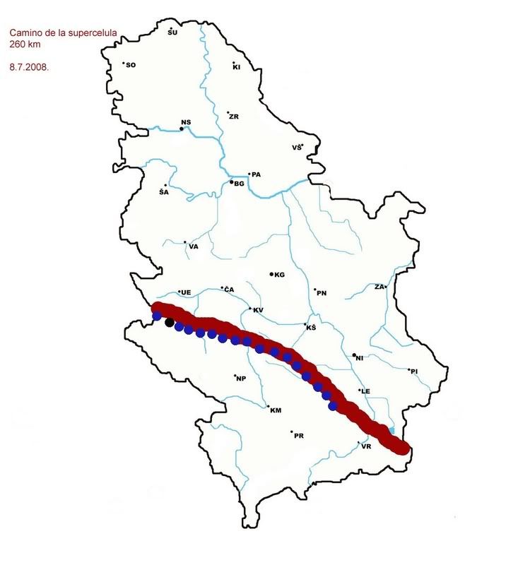
Azúl puntos es grande granizo,negro punto es posible tornado.Diario Blic informó proximo:

Very strong wind which couple days before blow in village near Nova Varos ,and destroyed parts of pine woods.
In wood called Bosanje,villagers found 30-50 meters wide and couple hundred meters long line of destroyed pines.
In Cajetina municipality fell hail of average size of walnut and maximum diameter of 8 cm.
Damages of large hail suffered villages in municipalities of:Priboj,Cajetina,Bajina Basta,Ivanjica,Kursumlija,Brus,Vladicin Han,Surdulica,Leskovac,Lebane,Bojnik,Medvedja.Hail was of average size of walnut.Damages to the crops was 10-80%.

Fortunately,path of the storm was through mountainous area,damages would be greater in plains.

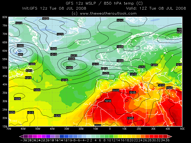
850hpa T 8.7.2008. 12z-12*C over northern Serbia,22*C over southern.


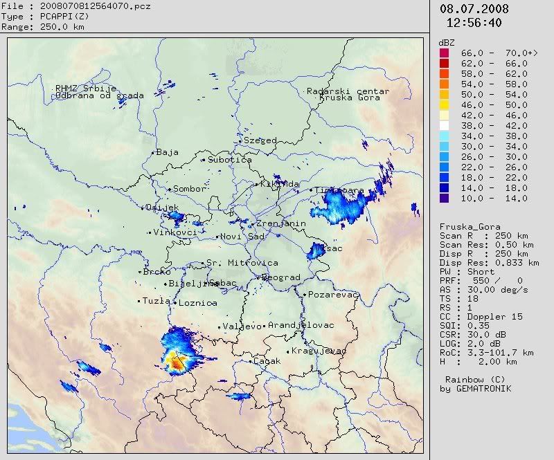
Doppler CAPPI 2km height image from radar center Fruska Gora-storm came in Serbia from Bosnia:


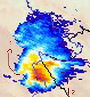
Classic supercell with 1. hook echo 2.V notch


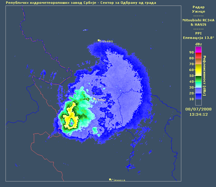
CAPPI 2 km height very weird image from radar center Uzice (que es esto?)   ???


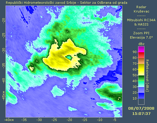
Storm is moving toward E SE,next images are from radar centar Krusevac:

CAPPI 2 km height,again hole in the cloud   ??? :


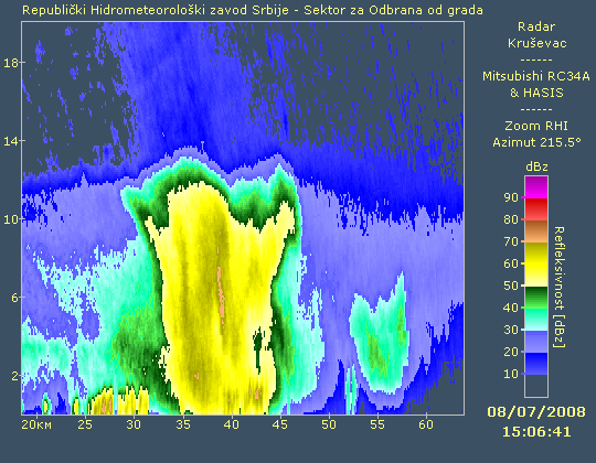
RHI image from radar center Krusevac:


At the end supercell came in southern Serbia,RHI from radar center Kukavica:


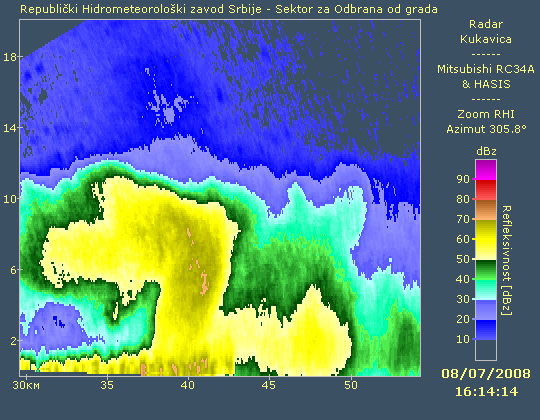
In this last image you can see very well zone of acumulation of hail,left upper part of the Cb is like storehouse for hail.

Damages of severe wind gusts reported in municipalities:Kursumlija,Bojnik,Vranje,Vladicin Han,Lebane.Blowed roofs,fallen trees,damaged crops,heavy precip (Kursumlija 44 mm) and possible tornado are epilogue of this storm.

Por desgrasia,ESTOFEX didnt issued forecast for that day.I was out of Belgrade in Southern Serbia,without internet,so i couldnt archive GFS maps  :( But i experienced this storm live,i made reportage about it  :D


« Última modificación: Enero 19, 2009, 19:11:50 pm por pavlovic »

soloestratos

  • Visitante
Re: Supercélulas en Serbia,año 2008.
« Respuesta #1 en: Enero 19, 2009, 19:22:53 pm »
Pavlovic good story :D1 :D1. That storm was amazing, at least we have gone through the mountains and did not create further damage.

Србија и чини се да имате невријеме, поздрав из El Ejido ( Almería ) ;) ;)

Desconectado Gale

  • Webmaster - Admin
  • Tornado F5 (Dedo de Dios)
  • ******
  • Mensajes: 45.768
    • Cazatormentas.Net
Re: Supercélulas en Serbia,año 2008.
« Respuesta #2 en: Enero 19, 2009, 19:48:54 pm »
Hi, Pavlovic :D :D :D!

Thanks for posting these radar images. They are very interesting, as I said to you this morning. I can't wait for the day in which we could see those products in the website of our Agencia Estatal de Meteorología :P :P :P

I'm sure that the hole corresponds with the BWER (Bounded Weak Echo Region, Región de Eco Débil Acotada in Spanish) of the supercell. I say this because I have seen that image:


Surely, the image with the hole is a CAPPI for a determinate height, with an angle respect to the ground, and perhaps this is the reason for seeing the hole... Do you understand?

I mean this:


Desconectado pavlovic

  • Cazatornados
  • Tornado F1
  • *****
  • Mensajes: 462
Re: Supercélulas en Serbia,año 2008.
« Respuesta #3 en: Enero 19, 2009, 21:12:55 pm »
So thats the point  :D
It looks very logic! And this CAPPI is on 2 km height,because of BWER,cloud looks on radar like it has hole.If radar made scan on 9,10 km height,this hole would be invisible.

Thanks Gale! 

Saludos ;)

Próximamente:"yo no quiero mover" supercélula 19.5.2008.
« Última modificación: Enero 19, 2009, 21:16:15 pm por pavlovic »

Desconectado Gale

  • Webmaster - Admin
  • Tornado F5 (Dedo de Dios)
  • ******
  • Mensajes: 45.768
    • Cazatormentas.Net
Re: Supercélulas en Serbia,año 2008.
« Respuesta #4 en: Enero 19, 2009, 21:23:21 pm »
I can't wait for this new story, Nikola :D :D :D

Could anyone take photographs of that storm? I supose that you have your own weather forums in Serbia. It would be nice if you can share photographs from Serbian Storm Chasers.

Gracias!! ;)

Desconectado pavlovic

  • Cazatornados
  • Tornado F1
  • *****
  • Mensajes: 462
Re: Supercélulas en Serbia,año 2008.
« Respuesta #5 en: Enero 19, 2009, 22:17:29 pm »
I post reportage here in cazatormentas about 8.7.2008. supercell,because i was in Southern Serbia then.


About 19.5.2008. supercell(?) we have no our pictures  :(
Gale,we have meteoforum in Serbia,i'm moderator there,but we have lack of stormchasers  :( So there is no real picture of the storm,just one from our member from Zrenjanin town.He made one picture of developing  storm (supercell(?) developed 30 km E SE from Zrenjanin).

I found some pictures of damage and one video on this link:
http://www.jasatomic.org.yu/?postid=7841  Jasa Tomic is place in Secanj municipality.
Pictures and video are recorded 23.5.2008.,four days after the storm.

So lets go  :D

Yo no quiero mover supercell(?) produced hail with maximum diameter 6 cm.

CAPPI 2 km height.16.05h radar image,from radar center Samos, indicate developing of supercell(?) SE from Zrenjanin,Banat region.Supercell(?) developed over teritory of municipalities Secanj and Zitiste.The most affected were villages Jarkovac,Boka,Konak,Surjan.


After 16h Cb grows,but stay based over same area. It just didnt want to move !!!

18h highest reflection.CAPPI 2 km Radar center Fruska Gora image:


CAPPI 16 km height Samos 18.02h:


RHI from Samos:


20.00h Supercell(?) is still over same area,but start to develope new Cbs on left

CAPPI 2 km height Fruska Gora radar center image:


20.30h supercell(?) over Secanj and Zitiste municipalities finally dies slovely,convective line develope left from supercell(?) and moving toward Zrenjanin:


Epilogue:
precip:more than 150 mm in 4.5 hours,on 13875 hectares de cultivos agricolas flooded and destroyed by hail,destroyed fruits,damage is estimated on 10000000 euros. (source:newspaper Kurir http://www.vesti.rs/exit/STETA-OD-DESET-MILIONA-EVRA.html note:you can use google translate to translate this news)

This storm hit small area but because it was based over same area more than 4 hours, was disastrous :(


Estofex:


My friend from serbian meteo forum reported event to ESSL:


Is this was supercell or multicell clusters.I'm little bit confused,because Estofex forecast multicell clusters,on Samos CAPPI 16 km height it looks like supercell and this storm lived long,that makes me to think that this was supercell,plus this storm didnt move like others near it.Fruska Gora CAPPI 2 km height 20.00h looks like clusters (omg i'm full of questions (i dont know basic things  :(:-X) ?
I think i should change name of topic into supercelulas y multicelulas  :-X


« Última modificación: Enero 19, 2009, 23:28:09 pm por pavlovic »

Desconectado Gale

  • Webmaster - Admin
  • Tornado F5 (Dedo de Dios)
  • ******
  • Mensajes: 45.768
    • Cazatormentas.Net
Re: Supercélulas en Serbia,año 2008.
« Respuesta #6 en: Enero 20, 2009, 09:47:35 am »
Wow, Nikola... These radar images are really impressive :o :o Let me to read it carefully, before telling you something about them :)

Thank you!

Desconectado pavlovic

  • Cazatornados
  • Tornado F1
  • *****
  • Mensajes: 462
Re: Supercélulas en Serbia,año 2008.
« Respuesta #7 en: Enero 21, 2009, 00:43:55 am »
Wow, Nikola... These radar images are really impressive :o :o   Thank you!

Yes Gale,and storm was impressive.More than 4h cloud didnt move from that area.Its very rare here in Serbia to see based storm which dont want to move.

Next what i will show you is landspout (dust tube tornado from multicell) 40-50 km NW from Belgrade near town Indjija.

May i rename topic into Tiempo severo en Serbia 2008.,porque yo voy post radar images from squall line storm which made pretty damage,and some multicells?

P.S. Whats mean this yellow pavlovic,i was blue pavlovic before?  :D

Saludos!  ;)
« Última modificación: Enero 21, 2009, 00:57:44 am por pavlovic »

Desconectado Gale

  • Webmaster - Admin
  • Tornado F5 (Dedo de Dios)
  • ******
  • Mensajes: 45.768
    • Cazatormentas.Net
Re: Supercélulas en Serbia,año 2008.
« Respuesta #8 en: Enero 21, 2009, 18:43:26 pm »
Surely, you want to mean green, not yellow :P Green stars in your profile means that you have been upgraded to tornadochaser, "cazatornados" in Spanish :D1 It is only an honour because you make a great efford to visit us regularly :D

Desconectado pavlovic

  • Cazatornados
  • Tornado F1
  • *****
  • Mensajes: 462
Re: Supercélulas en Serbia,año 2008.
« Respuesta #9 en: Enero 21, 2009, 19:42:29 pm »
Surely, you want to mean green, not yellow :P Green stars in your profile means that you have been upgraded to tornadochaser, "cazatornados" in Spanish :D1 It is only an honour because you make a great efford to visit us regularly :D

Ooops i dont know difference between yellow and green haha,i'm confused because all day i read book for my exams  :P  :P  :D
It's my pleasure to be here  :)

I have lack of time (have tomorrow important exam),so i will post just links to two pictures of lanspout near Indjija.

http://www.b92.net/info/galerija/zoom.php?nav_category=121&yyyy=2008&mm=6&start=306&image_id=76130

http://www.b92.net/info/galerija/zoom.php?nav_category=121&yyyy=2008&mm=6&start=306&image_id=76131

Tomorrow afternoon i will post something about tornadoes/landspouts in Serbia.
Saludos!  ;)
« Última modificación: Enero 21, 2009, 19:46:40 pm por pavlovic »

Desconectado pavlovic

  • Cazatornados
  • Tornado F1
  • *****
  • Mensajes: 462
Re: Supercélulas en Serbia,año 2008.
« Respuesta #10 en: Enero 22, 2009, 23:07:26 pm »
Buenas noches España  ;)

Map:


Since 2003. as map shows we had 5 confirmed events.My opinion is that most of this events are non supercell tornadoes (multicell tornadoes).Unfortunately i have no radar images of this clouds,and any picture of event (exept landspout near Indjija),because most of them happened near some small villages  :'(
You can see that we have 1 confirmed event of this type per year.
2004. event near Nova Varos.One woman was seriously injured when roof from one house fell on her car.Citizens of Nova Varos said that they had seen spout".Also,there were damages on houses only in one street,and nowhere other in the town.
2005. event in Rudna Glava.When people from Republic hydrometeorological service of Serbia came to estimate damage,villagers said that storm was produced by "cloud with leg" (cloud has "leg" to the ground).
2007. event near Kostolac.One man was injured when "mini tornado",as witnesses said,passed over archeological place Viminacium.Here is news:
http://arhiva.kurir-info.co.yu/arhiva/2007/jun/06/V-10-06062007.shtml
2007.my friend from hydrometeorological service found in his archive that 30.5.2007. landspout was reported at meteorological station Vrsac.This is first case of registered landspout at one meteorological station in Serbia.
2008. event near Indjija,i posted  link to pictures of event in previous post.

This is my reconstruction of radar image that day.I was waiting storm more than 2 hours,and at the end when it come near Belgrade just start to develop new cells northern of the city,so there was no storm in Belgrade.

Its clear that this was multicell storm:


I put black dot on cloud which produced landspout.

I marked some events,which by description could be landspaut,but could be just downburst.
It is event on Belgrade cementery Bezanijsko groblje 2005.
Event in Zajecar when people said that damages in part of that town produce "very strong whirling wind".
Event near Jagodina 2008.News reported that very stron wind damaged 50 houses (10-70% damages on houses) in village Koncarevo and in part of village Predor blow and crash 20 poplar trees.
Unclear is event near Nova Varos,i talk about it in presentation of supercell 8.7.2008.

The most famous tornado is happened near Valjevo 1993.It damaged houses in parts of villages Paune and Rajkovic.There is even published one research work about it.

Saludos,till next post about storms in Serbia  :D ;)
« Última modificación: Enero 22, 2009, 23:10:11 pm por pavlovic »

Desconectado pavlovic

  • Cazatornados
  • Tornado F1
  • *****
  • Mensajes: 462
Re: Supercélulas en Serbia,año 2008.
« Respuesta #11 en: Enero 27, 2009, 23:45:17 pm »
Buenas noches España  ;)

I will post something about storm 8.8.2008.
One child died in town of Vrsac,when tree fell on him during a storm.15 persons was injured in Belgrade when broken trees fell on them at Belgrade lake Ada Ciganlija.
It was very well organized convective system (squall line i think).First Cbs developed at Croatian coast:
Bilogora radar center (Croatia) animation,CAPPI 2 km height:


Around 14h (12 UTC) Cbs organized in Bosnia as squall line.
2 people died in Bosnia during this storm.

CAPPI 2 km height,Cb from Croatia entering Bosnia


Around 14.15h (12.15 UTC) line become more intense,moving toward Serbia.


15h (13h UTC).I think we can noticed BOW echo at this CAPPI 2 km height image:


15.45h


It seems that clouds become weaker at 16.15h (14.15 UTC)


System entering Serbia and it seems like Cbs dying.But gusts in Loznica exeeded 90 km/h

Fruska Gora RC image,CAPPI 2 km height


Next radar image discovered that system become strong again:
RC Bajsa 2 km CAPPI:


It looks like very nice BOW echo.Big wall of dust passed through Belgrade.Many trees fell down,roofs was blowed,15 persons were injured.
Gusts in Belgrade reached 28.2 m/s.
Here is reportage: http://www.cazatormentas.net/foro/reportajes-meteorolgicos/grande-tormenta-8-8-2008-belgrado-y-serbia/

Its moving toward east,causing damages in town of Smederevo,Kovin,finally killing 5 years old child in Vrsac (gusts 94 km/h).
In Banatski Karlovac gusts reached 115.3 km/h.

Image from RC Besnjaja,CAPPI 2 km height,line start to desintegrate slowely,but it pass over eastern Serbia and died somewhere in Bulgaria:


RHI from RC Petrovac


Path of this storm,from Croatia via Bosnia and Serbia was more than 400 km long.
This storm brings to Belgrade the second strongest wind gust in 2008. (First place have gust measured 1.3.2008 (30.6 m/s)).

Finally Cape Li chart:


Saludos!


« Última modificación: Enero 27, 2009, 23:53:09 pm por pavlovic »

Desconectado Gale

  • Webmaster - Admin
  • Tornado F5 (Dedo de Dios)
  • ******
  • Mensajes: 45.768
    • Cazatormentas.Net
Re: Supercélulas en Serbia,año 2008.
« Respuesta #12 en: Enero 28, 2009, 10:08:30 am »
A very interesting case, Pavlovic ;) I think as you: it was a very nice MCS showed as a bow echo. As you surely know, the last storm located at the southern extreme of the bow echo, can develop into a cyclonic supercell. At any case, this kind of storm structures is susceptible to generate very damaging "straight-line winds", as you have described.

Desconectado pavlovic

  • Cazatornados
  • Tornado F1
  • *****
  • Mensajes: 462
Re: Supercélulas en Serbia,año 2008.
« Respuesta #13 en: Febrero 12, 2009, 20:34:04 pm »
27.6.2008.
Heavy precip. and hail,especially in region of Cacak.
Damages caused by hail on crops:up to 20% in Valjevo municipality and up to 50% in Cacak municipality.

CAPPI 2 km height


Highest reflection near Cacak


RHI from RC Valjevo.


WER


BWER


RHI RC Uzice


Desconectado pavlovic

  • Cazatornados
  • Tornado F1
  • *****
  • Mensajes: 462
Re: Supercélulas en Serbia,año 2008.
« Respuesta #14 en: Marzo 02, 2009, 12:37:17 pm »
One offtopic sorry,but event was weird.Its happened 2005.

It's raining frogs in Serbia
07/06/2005 15:04  - (SA) 

Frog finds way into salad

Belgrade - Thousands of tiny frogs rained on a town in northwestern Serbia, Belgrade daily Blic reported on Tuesday.

Strong winds brought storm clouds over Odzaci, 120km north-west of Belgrade, on Sunday afternoon, but instead of rain, down came the tiny amphibians, witnesses said.

"I saw countless frogs fall from the sky," said Odzaci resident Aleksandar Ciric.

The frogs, different from those usually seen in the area, survived the fall and hopped around in search of water.

Belgrade climatologist Slavisa Ignjatovic described the phenomenon as "not very unusual".

"A wind resembling a tornado can suck in anything light enough from the surface or shallow water. Usually it is just dust, but sometimes also larger objects," Ignjatovic told Blic.

http://www.news24.com/News24/Technology/News/0,,2-13-1443_1717510,00.html

I found this news en espanol,but its published 2007. ,i dont know why  :-\

Lluvia de Ranas en Serbia.

El tráfico se detuvo y los vecinos huyeron a resguardarse luego de que miles de ranas cayeran desde el cielo sobre una aldea Serbia.

Los residentes en Odzaci contaron al diario local Blic que pensaron que era el fin del mundo.

Aleksandar Ciric dijo: "Ví todas esas pequeñas ranas comenzando a llover. Había miles de ellas."

Otro aldeano, Caja Jovanovic, agregó: "Esta 'nube' enorme parecía venir de ninguna parte y su forma y color lucían muy extraños."

"Todos nos preguntábamos que sucedía cuando las ranas empezaron a caer del cielo. Pensé que tal vez un avión transportando ranas había explotado en el aire."

Pero el experto en climatología Slavisa Ignjatovic afirmó que hubo una explicación simple para el incidente.

Dijo: "Un torbellino succionó las ranas desde un lago, mar o algún otro cuerpo de agua, llevándolas hacia Odzaci, en donde cayeron al suelo. Es un reconocido fenómeno científico.

http://senalesdelostiempos.blogspot.com/2007/04/lluvia-de-ranas-en-serbia.html


Buscas algun articulo o informacion? usa nuestro buscador