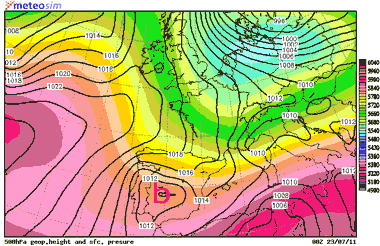
Sea level pressure (black lines) and geopotential height at 500 hPa (solid colours), next Saturday at 00 UTC. Credit: MeteoSIM.
22.07.11. In the last few weeks, the most common expression used by people has been «when will water become warmer?», as waters close to the western Mediterranean coast is still quite cool. Moreover, people is asking themselves when will the real summer arrive, with warm water, blue sky and hot. Let’s go with the details of the weather forecast.
Synopsis: the atmosphere is not still showing signs of complete estability, bringing completely clear sky, weak winds and hot temperatures to the Costa Tropical of Granada. All tourists wish this kind of weather in summer, especially if they travel to our region to enjoy of fair weather! For the next weekend, some little changes are forecasted, as a new trough is developing at high levels. Due to this reason, to make the weather forecast for the next weekend will not be easy. Lets go with the details, anyway:
Tomorrow: atmosphere will show some signs of a weak instability. Then, some scattered clouds are forecasted. There is a chance of a vertical growth of these clouds, over the main mountains above all, so isolated storms could develop. In this way, there is also a chance of some storms could reach the coastal-line of our region, from the Alboran Sea, early in the morning. At first hours, wind will blow from N, weakly, along the main valleys and the coastal line above all. In the moring, wind will turn to E & ESE, especially along the coastal-line. In the afternoon, it will turn to SW & WSW in that area. Blowing from variable direction, prevailing S, inland.
TEMPERATURE IN SALOBREÑA: MIN.: 20ºC – MAX.: 24ºC
Sea surface temperature (coastal waters): 22ºC
Sunday: there is some uncertainty. Nevertheless, a more estable weather is forecasted, although some scattered clouds could appear again. Wind will blow from N & NE weakly, early in the morning, especially along the main valleys and the coastal-line. Along that last area, wind will turn to SW in the afternoon, blowing weakly (breeze regime), with some moderate gust maybe. It will blow from S inland, weakly as well.
TEMPERATURE IN SALOBREÑA: MIN.: 20ºC – MAX.: 25ºC.
Sea surface temperature (coastal waters): 22ºC.
Don’t forget to take a look to the page on Facebook for the last updated data. You can leave there your comments and photographs if you want it.
![]()
Non-official weather forecast developed by Pedro C. Fernández. Based on several weather runs outputs. The Weather Station of Salobreña – Beah, provides its data online on Internet: www.cazatormentas.net/salobrena.html It is sponsored by “Freiduría ‘El Rey del Boquerón’” Restaurant, Hostal Palomares ** (www.hostalpalomares.com), “El Forajido” Restaurant (www.restauranteelforajido.com), Seafood/Shellfish Restaurant «El Trasmallo», the Patisserie/Ice-Cream parlor “Delicias del Rey Fernando”, the exclusive Clothing Store BOHEMIA, Mª José Parapharmacy (in front of the Mercado Municipal), all business of Salobreña, and the Chiringuito «El Último» in Torrenueva.
The copy of this weather forecast is forbidden.


Tú opinas